

Buckinghamshire, UK
Walks in and around Marlow - Contents
Walks starting in the Town
A partially circular walk, starting and ending at All Saints church, and a bit of history.
A circular walk, starting and ending at Higginson Park, along the river to Temple bridge and returning via a parallel path.
An interesting and informative walk around some of the historical highlights of the town.
Opens in a separate window. External sites may use cookies.
Directions to the Medical Facilities in Marlow: The Doctors House, Victoria Rd.
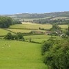
A Walk in the Country

2.5 miles
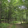
A mixture of woods and lovely open views. There are a number of medium gradients and one steep descent.
Fingest is 7 miles from Marlow, directions from Marlow town centre are: head north up Dean Street and continue for 4 miles to Lane End. Turn left towards Frieth. After 1 mile, just before Frieth, turn right at the crossroads. Continue to the end and turn left at the T junction. You will enter Fingest after about three quarters of a mile.
3.7 miles
A mixture of open fields (grazed by cattle) and woods, including the site of an Iron Age hill fort and settlement. There are few minor gradients and one medium to steep descent.
Medmenham is 3 miles west of Marlow on the A4155 Henley Rd and is on the Marlow to Henley (part of the Wycombe to Reading) bus route.
A wide range of downloadable (.pdf) leaflets detailing walks around the Chiltern Area
Opens in a separate window. External sites may use cookies.